The ‘precariously balanced boulders’ that offer a window into seismic history
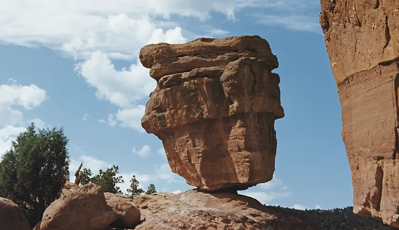
These giant rocks could roll at any moment. The fact they haven’t offers a window into the shaking of ancient Earth.
They look like you could blow them over with a sneeze. Across the world, thousands of “precariously balanced rocks” are perched in strange positions, poised to topple. Once they would have been mere geological curiosities. Now they are improving our understanding of earthquake risk.
The fact that these delicately positioned boulders still stand provides windows into deep history, long before modern-day seismometers could measure the shaking ground. “The only witnesses that we can consult are these precarious rocks – they’re the witnesses of what once happened,” says geologist Dylan Rood of Imperial College London in the UK.
This, in turn, is allowing us to prepare for the future, by improving the earthquake hazard maps which inform disaster plans, insurance premiums and building codes. These wobbly, gravity-defying rocks are even helping engineers stress-test nuclear power plants, radioactive waste repositories and enormous dams.
Fragile state
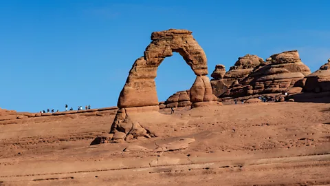
Precariously balanced rocks (otherwise known as PBRs) belong to a category of landform called “fragile geological features”. Some exist due to erosion, such as rock arches or tower-like pinnacles. On land, Arches National Park in Utah hosts thousands of these features, where rainwater or freeze-thaw action has weathered sandstone to the point of imminent collapse.
Meanwhile at the coast, the sea can carve fragile geological features into cliff-faces: arches form, until they eventually crumble, leaving behind sea stacks. One of the best-known stacks is the Old Man of Hoy in Scotland’s Orkney Islands, often ascended by climbers.
Other fragile geological features grow over time, like icicle-shaped stalactites or stalagmites. In some cases, they become many metres long, acquiring great weight, yet with a diameter no bigger than your arm.
All these features are striking to look at, but precarious boulders are particularly photogenic: they look like they could be megaliths, placed on a perch by some past civilisation or deity. You can find them all over the world: Brimham Rocks in Yorkshire, England; Krishna’s Butterball in India, and Kummakivi in Finland, to name just a few. In the US, they can be found scattered across several states, from the Metolius rocks of Oregon to Bubble Rock in Maine. In some countries, the rocks have even acquired religious significance: Buddhist devotees of the Golden Rock in Myanmar have coated it in gold leaf, and believe a strand of Buddha’s hair prevents it toppling
Precarious boulders gain their delicate balance for two reasons. Sometimes, glaciers have carried and dropped them in awkward positions. The forests of the northeastern US, for example, are peppered with these so-called “erratics”. Other times, the boulders only appear to have been placed on a perch: what’s actually happened is that their base has been gradually eroded to a narrow neck.
Windows to history
While hikers tend to visit precarious boulders for the selfies, seismologists admire these rocks for different reasons – because they can reveal earthquake activity during the deep past.
To appreciate how, you have to rewind to the early 1990s. Back then, geologists noticed a curious pattern in precarious boulders in California and Nevada: they were generally less abundant close to fault boundaries. This planted an idea: perhaps the rocks could reveal insights about ground shaking before precise seismometers were invented. If a precarious boulder is found in an area – and you can figure out how long it has been poised to fall – it means the ground has not rumbled enough to topple it.
Analysing them is improving the accuracy of earthquake hazard maps, especially for rare rumbles that only happen every few thousand years
One of the first boulders to be analysed in this way was Omak Rock in Washington State – a glacial boulder balanced on a tiny perch, around 90km (55 miles) south of the US-Canada border. Back in 1872, a severe earthquake shook the Pacific Northwest, but the technology of that time could not capture exactly how much the earth moved. Omak Rock’s survival on its perch helped geologists estimate an upper bound on how much shaking may have happened.
It’s even more difficult to assess earthquake impacts before human records began. In the field of paleoseismology, geologists look for signs of pre-historic ground motion like fault ruptures, landslides or tsunami detritus, but many quakes leave little trace in the geological record. When seismologists find precarious boulders that have stood for thousands of years, however, they serve as witnesses of such rare events. Analysing them is improving the accuracy of earthquake hazard maps, especially for rare rumbles that only happen every few thousand years.
In September, for example, researchers with the US Geological Survey published an analysis of precarious boulders left behind by glaciers in New York state and Vermont. Fortunately, there were no surprises – the boulders suggested their maps were broadly accurate – but that’s not always the case.

Two geologists who have helped to refine and fine-tune the analysis of precarious rocks are Anna and Dylan Rood – a married couple based at Imperial College London. They have developed a more precise, probability-based methodology for studying these seismic witnesses.
If you came across the Roods scrutinising a precarious boulder in the field, you’d know it was them because the rock would be peppered with coloured tape. Along with lidar (light detection and ranging) scans and drone photography, these markers help them to create 3D computer models of the rocks, so they can simulate what would happen to them in various earthquake scenarios.
“We can calculate the probability of that rock toppling across a range of ground shakings, from very short, small shaking up to really extreme shaking,” says Anna.
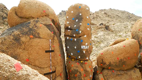
It’s also important to check the boulders were actually wobbly during past quakes. To date their precarity, the Roods analyse cosmogenic isotopes within the rocks’ quartz minerals, such as beryllium-10. These isotopes form when cosmic rays strike the quartz and are therefore more abundant when the rock’s surface has been exposed to the atmosphere. This reveals how long a boulder has stood on its narrow perch, or alternatively if its base was once buried in soil or other detritus. “It’s a clock,” explains Dylan. “We can model when the rock was exposed.”
With these techniques, the Roods have shown that some US hazard maps may require an update. By analysing precarious boulders at Lovejoy Buttes, close to the San Andreas fault in the Los Angeles region, they found the risks from a one-in-10,000-year quake may have been overestimated. The shake would be 65% less powerful in this region than previously estimated, they concluded.
Vital infrastructure
The Roods first met one another while analysing precarious rocks near the Diablo Canyon nuclear power station in California. Since then, they and their colleagues have shown that the boulders can be particularly useful for stress-testing vulnerable infrastructure, such as nuclear facilities or large dams.
In fact, precarious rocks have become so handy for the nuclear industry that the International Atomic Energy Agency (IAEA) now recommends they are studied for earthquake hazard mitigation near power plants. If engineers are risk-assessing a nuclear power station, they need to know about the impact of the rare “big one” that could crack open their reactor. However, if there hasn’t been one for millennia, it’s difficult to estimate how bad it could be.
When the Roods and colleagues mapped and analysed the boulders near the Diablo Canyon nuclear plant they were able to reduce the uncertainties in the hazard maps by nearly 50%. In late October, the pair were also due to begin studying France’s fragile geological features, after the energy company EDF asked them to enhance the seismic hazard maps for the country’s nuclear plants and hydroelectric dams.
In future, precarious boulders could also help engineers decide where to bury radioactive waste. One of the first test-cases for the rocks in nuclear planning was Yucca Mountain, a potential nuclear waste repository in Nevada (now-scrapped). Researchers at the University of Nevada, Reno analysed nearby precarious boulders coated in “rock varnish”, a clay-rich substance that builds up over long-term time in deserts. The varnish’s presence told them some precarious rocks had stood without falling for as long as 80,000 years – hinting the quake risk to Yucca Mountain was acceptable.
So, if you ever come across a precarious boulder when you’re out on a hike, consider what it may have survived to remain in place. Even the Roods themselves still marvel that some of these wobbly rocks are still standing. “At one of the sites in California, you could actually rock them yourself. It really puts into context how fragile these are,” says Dylan.

