Israel wants to close the circle of history in Gaza
Lorenzo Kamel
Over the past year, Gaza has become synonymous with epochal catastrophe. But in ancient times, this was a place of prosperity, a strategic crossroads known as “the way of the Philistines”, which connected ancient Egypt with the land of Canaan.
Gaza is mentioned in the inscriptions of the Egyptian Pharaoh Thutmose III (1481–1425 BCE) in relation to his first military campaign in Asia. About 2,700 years later, the famous Tangier traveller Ibn Battuta (1304-1368 CE) visited Gaza and wrote that “it is a place of large dimensions … it has no wall around it”.
In the 19th century, Gaza – under Egyptian and Ottoman rule – was not only an important trade hub, but also famous for its agriculture. Historian Nabil Badran wrote that in the 1870s there were around 468 hectares (1,156 acres) of irrigated citrus groves in the Gaza area. In an 1867 memoir, James Finn, a former British consul in Jerusalem, recalled: “Another hour brought us to Asdood [Ashdod] of the Philistines, with Atna and Bait Daras on our left. I do not know where in all the Holy Land I have seen such excellent agriculture of grain, olive-trees, and orchards of fruits, as here at Ashdod.”
During the British Mandate, Gaza was one of the 16 districts of Palestine and it also encompassed Isdood (Ashdod) – which, in 1945, had a population of 4,620 Palestinians and 290 Jews – Asqalan (Ashkelon), and some parts of the western Naqab (Negev) desert.
When Gaza became a ‘strip’
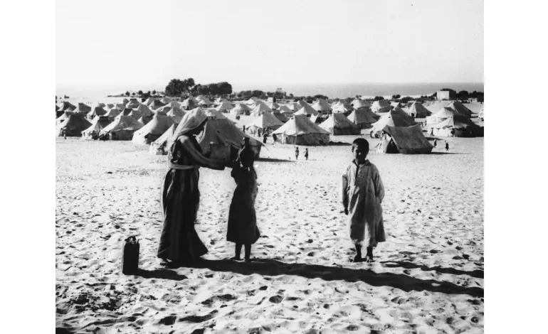
The idea of a “Gaza Strip” is more recent. It is the result of the tragic history of the last 76 years, which can be summarised in one number: about 70 percent of its inhabitants come from families of refugees expelled by Zionist forces from Bait Daras, Simsim, Najd, Majdal, Huj, Abu Sitta, and dozens of other villages before and during the Arab-Palestinian-Israeli war of 1948.
Palestinians call the expulsions and the destruction of 418 of their villages, “al-Nakba”, the catastrophe. It should be noted that the expression Nakba was not initially used by the Palestinians. While this is an Arabic word, it was used for the first time in relation to Palestine in the leaflets dropped by the Israeli army planes on the town of at-Tira near Haifa in July 1948, with the purpose of persuading Palestinians to surrender and leave their homes and villages.
It was at that historical juncture that Gaza became the main hub for Palestinian refugees.
In the words
Michael Gallant, father of Israeli Defence Minister Yoav Gallant, took part in that operation. He named his son Yoav to celebrate the military campaign that, more than any other, changed Gaza’s demography.
Today, Yoav Gallant, along with other Israeli officials, is trying to close the circle of history, this time by “thinning” the Palestinian population of Gaza. A document produced by Israel’s Ministry of Intelligence leaked to the press in late October last year outlined the forcible and permanent transfer of Gaza’s 2.3 million Palestinian residents to Egypt’s Sinai Peninsula.
This idea is hardly unprecedented.
In 1953, Egypt, together with the United Nations agency for Palestinian refugees (UNRWA) and the United States, agreed on the resettlement of 12,000 Palestinian refugee families from the Gaza Strip to the Sinai Peninsula.
Following the war of 1948, Gaza had remained under Egyptian control. Cairo feared that the Palestinian resistance, which was growing by the day back then, could drag it into a confrontation with Israel, which it was keen to avoid. That is why, it was willing to go along with the plan, even at the expense of Palestinian rights, hoping it would help relieve pressure.
of Palestinian author Toufic Haddad, Gaza was “one of the few Palestinian cities that survived the 1948 Nakba … Gaza City became a city that was teeming with all these refugees who were displaced from their lands, and subsequently it became the seat of the first attempt to try and form an all-Palestinian national government after 1948”.
Gaza’s demographic (un)balance
In mid-October 1948, the Israeli army launched Operation Yoav a counteroffensive against the Egyptian forces in the Naqab. As a result, the refugee population in Gaza jumped from 100,000 to 230,000.
Michael Gallant, father of Israeli Defence Minister Yoav Gallant, took part in that operation. He named his son Yoav to celebrate the military campaign that, more than any other, changed Gaza’s demography.
Today, Yoav Gallant, along with other Israeli officials, is trying to close the circle of history, this time by “thinning” the Palestinian population of Gaza. A document produced by Israel’s Ministry of Intelligence leaked to the press in late October last year outlined the forcible and permanent transfer of Gaza’s 2.3 million Palestinian residents to Egypt’s Sinai Peninsula.
This idea is hardly unprecedented.
In 1953, Egypt, together with the United Nations agency for Palestinian refugees (UNRWA) and the United States, agreed on the resettlement of 12,000 Palestinian refugee families from the Gaza Strip to the Sinai Peninsula.
Following the war of 1948, Gaza had remained under Egyptian control. Cairo feared that the Palestinian resistance, which was growing by the day back then, could drag it into a confrontation with Israel, which it was keen to avoid. That is why, it was willing to go along with the plan, even at the expense of Palestinian rights, hoping it would help relieve pressure.
Israel wants to close the circle of history in Gaza
In 1948, Gaza became a haven for refugees. Now it may face the same fate as other depopulated Palestinian lands.

Over the past year, Gaza has become synonymous with epochal catastrophe. But in ancient times, this was a place of prosperity, a strategic crossroads known as “the way of the Philistines”, which connected ancient Egypt with the land of Canaan.
Gaza is mentioned in the inscriptions of the Egyptian Pharaoh Thutmose III (1481–1425 BCE) in relation to his first military campaign in Asia. About 2,700 years later, the famous Tangier traveller Ibn Battuta (1304-1368 CE) visited Gaza and wrote that “it is a place of large dimensions … it has no wall around it”.
In the 19th century, Gaza – under Egyptian and Ottoman rule – was not only an important trade hub, but also famous for its agriculture. Historian Nabil Badran wrote that in the 1870s there were around 468 hectares (1,156 acres) of irrigated citrus groves in the Gaza area. In an 1867 memoir, James Finn, a former British consul in Jerusalem, recalled: “Another hour brought us to Asdood [Ashdod] of the Philistines, with Atna and Bait Daras on our left. I do not know where in all the Holy Land I have seen such excellent agriculture of grain, olive-trees, and orchards of fruits, as here at Ashdod.”
During the British Mandate, Gaza was one of the 16 districts of Palestine and it also encompassed Isdood (Ashdod) – which, in 1945, had a population of 4,620 Palestinians and 290 Jews – Asqalan (Ashkelon), and some parts of the western Naqab (Negev) desert.
When Gaza became a ‘strip’
The idea of a “Gaza Strip” is more recent. It is the result of the tragic history of the last 76 years, which can be summarised in one number: about 70 percent of its inhabitants come from families of refugees expelled by Zionist forces from Bait Daras, Simsim, Najd, Majdal, Huj, Abu Sitta, and dozens of other villages before and during the Arab-Palestinian-Israeli war of 1948.


