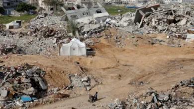
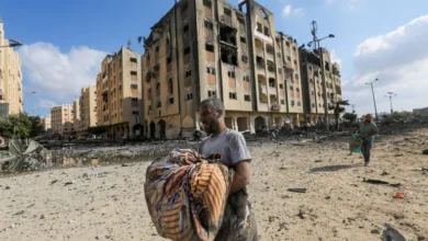
Where are Gaza’s neighbourhoods destroyed by Israel?
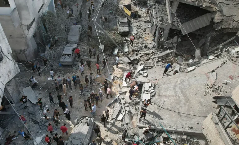
The Gaza Strip has sustained widespread destruction as the Israeli military has bombarded the besieged enclave of 2.3 million people for more than two weeks. Even its south, which Israel had declared a safe zone, has not been spared.
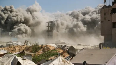
Satellite imagery and photographs show entire neighbourhoods have been levelled with many hospitals, schools, places of worship and homes damaged or destroyed by Israeli land, sea and air attacks.
In the following infographic series, Al Jazeera maps out Gaza’s damaged communities and neighbourhoods across the strip’s five governorates: North Gaza, Gaza City, Deir el-Balah, Khan Younis and Rafah.
Gaza’s densely populated neighbourhoods
Bordered by Israel and Egypt on the Mediterranean coast, the Gaza Strip is 365sq km (141sq miles). At only 41km (25 miles) long, it can take less than an hour to drive from Beit Hanoon in the north to Rafah in the south.
The Palestinian enclave has a population of 2.3 million people, including 1.7 million refugees who were ethnically cleansed from areas that now form part of Israel. Most refugees live in or near Gaza’s eight refugee camps.
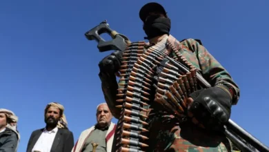
Since 2007 when Hamas came to power, Israel has maintained strict control over Gaza’s airspace and territorial waters and restricted the movement of goods and people in and out of Gaza.
North Gaza extends for 10km (6 miles) and shares the only crossing into Israel through Beit Hanoon, also known as the Erez crossing. North Gaza is home to the Jabalia refugee camp, the largest in the strip.
The 61sq-km (24sq-mile) area is home to 440,000 people and includes the following communities and neighbourhoods: Beit Lahiya, Beit Hanoon, Jabalia refugee camp, Madinat al-Awda and Jabalia al-Balad.
Jabalia refugee camp
The Israeli military has repeatedly hit the Jabalia camp, including on October 9, 12, 19 and 22 killing more than 150 people. The camp houses three United Nations-run schools, which have been converted into shelters for hundreds of displaced families.
Rimal neighbourhoods
At the heart of the Rimal neighbourhoods is al-Shifa Hospital, the largest medical facility in the Gaza Strip.
Tens of thousands of displaced Palestinians are sheltering at the hospital, where Palestinian doctors are warning of an impending infectious disease outbreak due to overcrowding.
Surrounding the hospital are several UN compounds, including the Relief and Works Agency for Palestine Refugees (UNRWA), the Office of the UN Special Coordinator for the Middle East Peace Process (UNSCO) and the UN Development Programme (UNDP).
Gaza’s top universities – including the Islamic University of Gaza, Al-Azhar University-Gaza and Al-Aqsa University, which are just a few hundred metres apart – are also located in Rimal.
On October 7, Israeli warplanes destroyed the Palestine Tower, a 14-storey residential tower in Rimal, reducing it to rubble. The moment was captured live on camera behind Al Jazeera’s Youmna ElSayed.
Shati refugee camp
Israeli attacks have targeted the Shati refugee camp, also known as Beach Camp, several times, terrifying its 90,000 inhabitants living on 0.52sq km (0.2sq miles) of land. On October 9, Israeli strikes destroyed the Yassin Mosque, one of at least 11 mosques that have been destroyed since October 7.
Tal al-Hawa
On Wednesday, Israeli strikes hit areas near al-Quds Hospital in Tal al-Hawa. More than 8,000 Palestinians had taken refuge at the hospital, which was previously destroyed by Israeli forces in 2009.
Old City
Just north of the Zeitoun neighbourhood is Gaza’s Old City, which is home to several historical sites, including the Great Omari Mosque, known as Gaza’s Great Mosque, and two of Gaza’s churches: St Philip the Evangelist Chapel and St Porphyrius Church.
On Tuesday, a massive blast at al-Ahli Arab Hospital, also in the Old City, killed nearly 500 Palestinians, many of whom were taking shelter from Israeli bombing. The Ministry of Health in Gaza said the blast was caused by an Israeli air raid. Israel has attributed the explosion to a misfired rocket launched by the Palestinian Islamic Jihad (PIJ) armed group. The PIJ has denied the allegation. An Al Jazeera investigation has debunked Israel’s claim.
Two days later, an Israeli air attack killed at least 18 people who were sheltering in the St Porphyrius Church, Gaza’s oldest church, which was built between the 1150s and 1160s. A Palestinian pastor has called the bombing of St Porphyrius, where hundreds of people had taken refuge, a “war crime”.
Shujaiya
One of the largest neighbourhoods in Gaza City is Shujaiya, which in Arabic means “courage”.
Shujaiya has experienced extensive destruction in past Israeli military offensives. A particularly devastating episode occurred in July 2014 when the densely populated district bore the brunt of heavy tank and artillery shelling that killed 72 people and injured more than 200 in a single day. The incident drew widespread international criticism and condemnation.
The drone footage below, shot in 2014, shows the remains of Shujaiya after Israel’s 50-day-assault.
Al-Zahra
On the outskirts of Gaza City are the neighbourhoods of al-Zahra, al-Mughraqa and Juhor ad-Dik, which have also been hit by Israeli raids.
In al-Zahra, Israeli attacks have levelled at least 10 buildings and left thousands of people either trapped in the rubble or awaiting medical care.
Beginning at Wadi Gaza, a river that divides Gaza roughly into north and south, Deir el-Balah is named after the Monastery of the Date Palm and is one of Gaza’s largest agricultural producers.
Gaza’s only operating power plant is located along the district’s boundary with Gaza City.
Deir el-Balah is also home to four out of Gaza’s eight refugee camps: Nuseirat, al-Bureij, al-Maghazi and Deir el-Balah.