Inside Qeshm, Iran’s underground missile fortress and geological marvel
Beneath the labyrinthine salt caves and emerald mangrove forests of Qeshm Island in the Strait of Hormuz, a different kind of architecture lies buried.
While tourists once flocked to this “open-air geological museum” to get a glimpse of its surreal rock formations, the world’s gaze is now fixed on what lies beneath the coral: Iran’s “underground missile cities”.
As the United States-Israel war on Iran has erupted, Qeshm has transitioned from a free-trade and tourists’ paradise to a front-line fortress – and the ultimate strategic prize for US Marines currently being deployed to the strait.
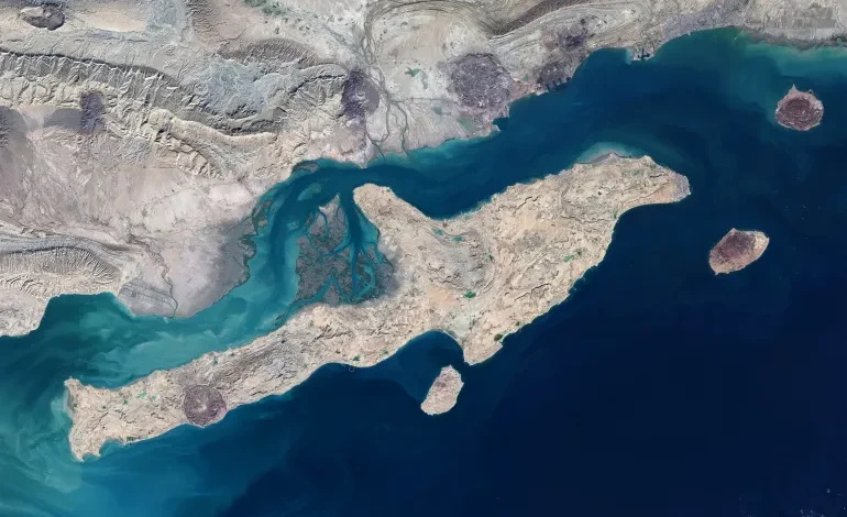
Its sheer size – approximately 1,445 square kilometres (558 square miles) – allows it to physically dominate the entrance to the strait from the Gulf, acting as a cork in the world’s most vital energy transit passage.
These days, the island’s 148,000 residents – primarily Sunni Muslims who speak the unique Bandari dialect – live at the intersection of this ancient natural beauty and modern military tensions. Their lives are still dictated by the sea, which is celebrated every year during the “Nowruz Sayyadi” (Fisherman’s New Year), when all fishing stops to honour the ocean’s bounty.
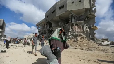
But on March 7 – one week into the war on Iran – US air strikes targeted a critical desalination plant on the island. The strike, which Tehran branded a “flagrant crime” against civilians, cut off fresh water supplies to 30 surrounding villages.
In a swift retaliatory move, the Islamic Revolutionary Guard Corps (IRGC) launched strikes against US forces at the Juffair base in Bahrain, alleging the attack on Qeshm had been launched from a neighbouring Gulf state.
‘Missile cities’ – the fortress in the strait
Today, the island’s modern industrial facade, bolstered by its status as a Free Trade-Industrial Zone since 1989, is overshadowed by its role as Iran’s “unsinkable aircraft carrier”.
Located just 22km (14 miles) south of the port city of Bandar Abbas, Qeshm dominates the Clarence Strait (Kuran) and acts as the primary platform for Iran’s “asymmetric” naval power, say analysts.
While exact figures regarding the number of Iranian fast-attack boats and coastal batteries hidden within the island’s subterranean labyrinths remain heavily classified, their strategic intent is clear. Retired Lebanese Brigadier General Hassan Jouni, a military and strategic expert, told Al Jazeera that Qeshm houses “striking Iranian capabilities” within what is described as an underground “missile city”. These vast networks, Jouni said, are designed for one primary purpose: to effectively control or close the Strait of Hormuz.
This, they have successfully done. Shipping traffic through the strait was effectively halted last week when Iran threatened to strike ships attempting to pass.
Now, only a handful of ships carrying vital oil and gas supplies to the rest of the world are being allowed through, as countries scramble to negotiate deals with Iran for their own tankers and as the administration of US President Donald Trump attempts to assemble a naval convoy of warships to forcibly open the waterway.
As Qeshm becomes the focal point of a 21st-century energy war, however, its silent salt caves and ancient shrines serve as a reminder that while past empires and military coalitions like those of the Portuguese and British have eventually faded, the geological fortress of the strait remains anchored in the turbulent tides of history.
An island of many names
Known in Arabic as Jazira-al-Ṭawila (the Long Island), Qeshm’s identity was forged by a succession of empires.
According to the Encyclopaedia Iranica, the Greek explorer Nearchus referred to it as Oaracta, and saw the legendary tomb of Erythras, the namesake of the Erythraean Sea, there. By the 9th century, Islamic geographers were referring to it as Abarkawan, a name later folk-etymologised as Jazira-ye Gavan or “Cow Island”.
The island was deemed so strategically important that the rulers of Hormuz moved their entire court there in 1301 to escape Tartar attacks. For centuries, it served as the “water barrel” of the region, providing vital drinking water to the arid Kingdom of Hormuz on the eastern side of the Persian Gulf.
The island’s wealth was so legendary that in 1552, the Ottoman commander Piri Reis raided it, seizing what contemporary accounts described as “the richest prize that could be found in all the world”.
The island’s colonial history is equally turbulent.
The Portuguese built a massive stone fort on Qeshm in 1621. And a year later, a combined Persian and English force expelled the Portuguese from that fort in a battle that claimed the life of Britain’s famed Arctic navigator William Baffin.
By the 19th century, the British had established a naval base at Basidu (Bassadore), which remained a hub for the British Indian Navy until 1863. It wasn’t until 1935 that the British coaling station was finally abandoned at the request of Reza Shah Pahlavi, the then-shah of Iran.
The island’s landscape includes:
The Valley of Stars: A complex network of canyons and rock pillars carved by millennia of erosion. Local legends claim the valley was formed by a falling star that shattered the earth.
Namakdan Salt Cave: One of the world’s longest salt caves, stretching for more than 6km (3.7 miles). Its crystalline formations are hundreds of millions of years old, containing some of the purest salt in the Persian Gulf.
Chahkooh Canyon: A deep, narrow corridor of limestone and salt, where vertical walls create a natural cathedral of stone.