How climate change is rewriting the rules of extreme storms
The behaviour of the world’s most powerful storms is evolving. To adapt to more destructive hurricanes, typhoons and tropical cyclones, we need to know how they’re changing.
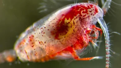
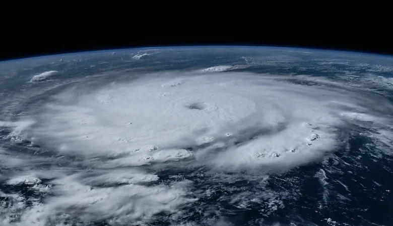
Fuelled by heat from ocean waters, hurricanes, typhoons and tropical cyclones are sometimes known as nature’s steam engines. As they barrel over the oceans, they turn its heat into brutal kinetic energy that flattens islands and inundates coastal cities, taking months of urgent repair work to heal. Ocean temperatures are now breaking all records, and these “engines” are responding accordingly, cutting different paths across the ocean, slowing down, and becoming less predictable and more dangerous.
Now there’s a race to understand exactly how hurricanes are rewriting the rules and patterns we’ve seen before, in the hope of learning how we can adapt.
A longer season
There’s a distinct seasonal cycle to hurricanes in the Atlantic, with very few or none at all in winter, and a peak in September. A strong, early start to the hurricane season is in line with what we would expect with climate change, says James Kossin, a climate and atmospheric scientist retired from the US National Oceanic and Atmospheric Administration (Noaa).
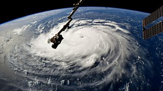
Typhoon Bebinca
On the morning of 16 September, powerful Typhoon Bebinca made landfall near Shanghai, China. The typhoon was the most powerful storm the city has seen in 75 years, according to Chinese state media.
Hundreds of thousands of residents were evacuated in advance of the arrival of the storm.
“Hurricanes themselves just respond to the environment that they’re sitting in,” Kossin says. “And so if you make the environment in June look like the environment that would normally be in August or September, then the hurricanes will simply behave as though it’s August or September. They don’t have a calendar.”
The extraordinarily warm ocean conditions we’re seeing now are driven by climate change, though there are other factors that have made this an active season, such as the present transition from El Nino to La Nina, which tends to boost storm activity.
“In a warming climate, we would expect the waters to be at the warmth that we need for hurricane earlier in the year,” says Kristen Corbosiero, associate professor in the department of atmospheric and environmental sciences at the University at Albany in New York. “So it’s certainly possible that we will see earlier seasons and longer hurricane seasons moving forward.”
While the intense early start to the 2024 season with Hurricane Beryl is in line with what climate scientists might expect to see with climate change, it’s too early to observe a consistent shift in the season. “[It’s] not something that appears clearly in the data yet,” says Suzana Camargo, professor of ocean and climate physics at Columbia University.
‘Shear is death’
One of the strongest storms to form recently in the Atlantic did so under conditions that ought to have prevented a hurricane from forming, says Hugh Willoughby, research professor in earth and environment at Florida International University.
In September 2023, at the peak of the Atlantic season, Hurricane Lee rapidly intensified into a category five storm. At the time, an El Niño was in effect, which generally has a stifling effect on storms in the Atlantic due to greater wind shear and atmospheric stability.
“Shear is death for hurricanes,” says Willoughby. Vertical wind shear is the change in wind speed and direction at different heights – high wind shear disturbs the structure of a hurricane. “Imagine you’ve got a turbine engine – shear knocks some of the blades out,” says Willoughby.
So for a category five like Hurricane Lee to form despite considerable shear came as “a nasty surprise”. The extraordinary ocean warmth in September 2023 may have somehow overwhelmed the influence of shear, says Willoughby, though it’s not entirely clear why.
“We, the theoreticians, need to think about that.”
Faster intensification
The vast majority of hurricanes that form in the Atlantic don’t reach their potential, says Willoughby. In the relatively tight constraints of the Atlantic Basin a storm will often make landfall before it reaches peak intensity, or it will run into high wind shear, which helps dissipate the storm.
“But when everything goes right it’ll intensify rapidly and reach its maximum potential intensity, which is defined by the ocean surface temperature below the hurricane,” says Willoughby.

There is “a heck of a lot of evidence” that intensification rates are increasing as oceans get hotter, providing more fuel to the storms, says Kossin.
“It all comes down to the amount of fuel available,” he says. “It’s kind of like changing the jets in a carburettor. You change the jets to allow for more fuel to come in and mix with the air, you’re going to get more horsepower. You’re going to be able to go from zero to 60 faster. And that’s your intensification.”
Stronger peak intensity
The peak intensity of hurricanes has also been rising with climate change. In a 2020 study, Kossin found the intensity of storms between 1979 and 2017 increased by about 6% per decade. Storms are now 25% more likely than they were 40 years ago to reach the threshold of 111 mph (180km/h) required to be classified as a major hurricane.
Overall, the proportion of tropical cyclones of category three or more is likely increasing, according to the International Panel on Climate Change (IPCC).
“The ocean temperature defines the maximum intensity the hurricane can reach,” says Willoughby.
In May 2024, the world’s ocean temperatures had broken records every single day for the preceding year.
Slowing down
Even as the wind speeds within a hurricane speed up, the movement of hurricanes along their paths over ocean and land is slowing down.
In a 2018 study, Kossin found that hurricanes near the US have slowed by around 17% since the beginning of the 20th Century. Tropical cyclones in the western North Pacific slowed down by as much as 20%.
It’s thought that the reason for the slowdown is the uneven way that climate change is heating the globe, with the Arctic warming nearly four times faster than the rest of the world. As a result, the difference in temperature between the Arctic and the tropics is narrowing. “It’s that temperature gradient that drives the winds,” says Kossin. “The stronger the gradient, the stronger the winds.”
You can think of hurricanes like a cork in a stream, he says. “They just go where the wind takes them.” And if you slow down the winds, you’re going to slow down the storms as they move along their path.
Expect more rain
A slow-moving hurricane has more time to dump rain in a given location – think of the difference between passing a garden hose quickly over a flowerbed or holding it in place for longer. One particularly slow-moving category one storm, Hurricane Debby, was forecast to bring as much as 30in (76cm) of rain and catastrophic flooding as it swept north from Florida’s Gulf Coast on 5 August 2024 into Georgia and South Carolina.
“What really is going to give you a lot of rain is when you slow these [storms] down,” says Kossin. “When they stop, or what we call ‘stall out’, it’s just devastating because you get inundated for days.”
The damage caused by wind, too, increases with its duration – the longer it blows against structures, the more likely it will knock them over. “It’s just bad having a hurricane stick around very long,” Kossin says. “You want it to get out of your neighbourhood.”
There’s also the fact that warmer air can hold more moisture – around 7% more per degree Celsius, which means hurricanes can become even wetter. As climate change increases temperatures, that extra moisture makes a difference – but the effect is small compared with the difference made by a hurricane that’s stalling out, says Kossin.
For this reason, Kossin says he sees this slowdown as the most dangerous of all the ways climate change is altering hurricanes. “That’s a really big deal.”
Churning waters offer less protection
As well as very high temperatures at the uppermost layer of the ocean, things get worse when the layers below start to warm up too. If the upper warm layer is shallow then as the hurricane passes over, cooler water from below gets churned up and mixes in, says Corbosiero, cooling the surface water down.
“But if that warm water extends to a deeper layer as the hurricane goes by and churns up the water, the [surface] water is still warm,” says Corbosiero, allowing the storm to continue with force.
These are conditions that we’re seeing in the Atlantic. “In addition to warm surface waters, we also have very deep warm waters right now,” she says. “So [hurricanes] are able to intensify faster and not stop intensifying because they’re not encountering cold water.”
Hurricanes are changing track
There’s a danger of getting tunnel vision when considering the ways hurricanes are changing, says Kossin, with the focus on strength and intensification. “People don’t talk about track enough,” he says. “And I think that it’s by far more dangerous.”
In a 2014 paper, Kossin and colleagues found that in the northern hemisphere, storms had moved north by 53km (33 miles) per decade. In the southern hemisphere, they had moved south at 62km (39 miles) per decade. In all, the hurricanes were moving about one degree of latitude away from the tropics per decade.
This could expose communities to extreme storms in regions previously unused to them. Kossin points to the migration of tropical cyclones in the Western Pacific, where he has measured a slight decrease in risk around the Philippines, but an increase to the north near Japan.

“The Philippines experiences [cyclones] all the time, so they’re somewhat adapted to it. Japan experiences them, but not all the time,” says Kossin. “So now we’re saying that they’re going to start seeing stronger storms reaching them than before. The effect that that has on risk is really substantial.”
The US’s protective barrier is failing
Climate change is also altering the patterns of wind shear over the Atlantic.
“There’s a pattern of wind shear that is sort of like two bullseyes,” says Kossin. One elongated bullseye sits in the Main Development Region (MDR), a strip of the tropics hurricanes move through and intensify in. The second bullseye is just off the east coast of Florida, extending up to the Carolinas.
“Those two have a kind of a seesawing effect,” says Kossin. “When the shear is high in the MDR it tends to be low off of the coast there, and vice versa.”
The shear in the MDR is linked to sea surface temperatures – warmer waters here generally means less shear. In turn, that often means greater shear off the US coast – resulting in a shield of messy winds that acts as an “intensification barrier”, as Kossin discovered in 2017. While this barrier unfortunately does nothing to weaken storms as they hit communities in the Caribbean, it does offer the US some protection.
“So when the conditions are conducive for lots of storms forming and intensifying in the MDR, as they approach the US, they run into this higher shear and it tends to weaken them,” says Kossin. “Fortunately, for now.”
But this protective barrier does not appear to be a permanent fixture. In a paper authored by Kossin and Camargo and colleagues at Columbia University, the researchers looked at what the future might hold for this barrier.
“Sure enough, it seems like the news is always bad, right?” says Kossin. “It’s never good. It could have been good. We could have found that climate change increases the barrier. But it doesn’t. It erodes it.”
Loss of a smog shield
In addition to greenhouse gas levels rising, a decrease in air pollution in Europe and the US since the 1970s is thought to have had an unintended consequence – warming the air over the Atlantic further.
Previously, high levels of sulphate pollutants from industry mixed over the Atlantic Basin, hindering sunlight from hitting the ocean, says Kossin. “And that has a cooling effect.”
Climate change has been well underway since the industrial revolution, “but we’ve been suppressing that warming with this pollution”, says Kossin. After the remarkable success in reducing industrial pollution, that cooling effect reduced.
There is debate over just how much industrial smog may have influenced temperatures. Willoughby believes the impact was small, with other factors playing a more important role on ocean temperatures. Some studies have found, however, that industrial smog’s influence on ocean temperatures is underappreciated, with clean-up efforts in China potentially contributing to periodic warm “warm blob” events in the north-east Pacific.
There are other ways too that hurricanes are becoming more extreme and bringing greater risk.
“Sea level rise is also happening underneath everything we’re talking about, and since hurricanes become dangerous as they move onto a coast, you always have to add that on to the problem,” says Kossin.
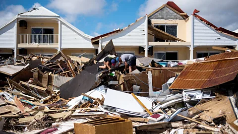
One study found storm surge waves from hurricanes in the Caribbean, Mexico and the US had grown in area by 80% since 1979 – and globally, storm surge waves were also getting around 3% higher per decade.
But technologies can help save lives in communities where hurricanes make landfall, while longer-term changes could also limit loss of life and property.
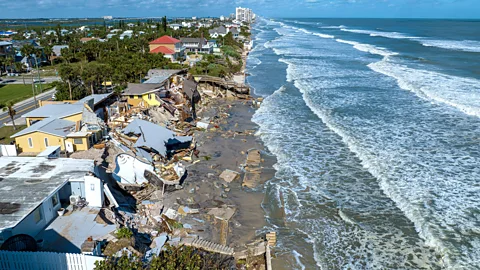
“One of the issues I would focus on is [limiting] further development of the coastal regions,” says Carmargo. “Policies that lead to huge real estate development in the coastal regions should not continue. The more people and more infrastructure in regions that are typically in the path of hurricanes lead to more impacts.”
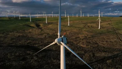
For those who do live in the paths of hurricanes, making broad adaptations to buildings and developments may help preserve homes and infrastructure. Reliable early-warning systems, meanwhile, can provide a life-saving head-start to safety. There could also be natural solutions to help bolster island and coastal areas, from planting grass that binds slopes together to replenishing lost oyster beds.
“Adaptation is so important, and you know, may ultimately turn out to be the most important thing,” says Kossin. “Because we can’t suddenly turn off climate change and have everything go back to the way it was. There’s an inertia to the system that we can’t really get past. And so adaptation is going to be a big part of it.”