Erin rapidly intensifies to category five hurricane
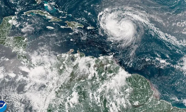
Hurricane Erin has rapidly intensified into a rare category five hurricane, packing maximum sustained winds of 160mph (260km/h), and expected to gain even more strength.
National Hurricane Center Director Mike Brennan told a briefing that the “extremely powerful” storm had “explosively deepened and intensified” overnight after growing from tropical storm strength on Friday.
Erin is in the Caribbean, expected to pass north of the Leeward Islands, the Virgin Islands and Puerto Rico this weekend, bringing up to 6in (15cm) of rain, with potential for flash flooding and mudslides.
The first hurricane the 2025 Atlantic season, it is not currently forecast to make landfall on the mainland US.
Hurricane Erin underwent rapid intensification, in which a storm strengthens by at least least 34mph in a 24-hour period.
Erin’s winds had intensified from 100mph early in the hours of Saturday morning to 160mph, Mr Brennan said.
Next week, Hurricane Erin is forecast to move gradually northward, past the east of the Bahamas and up towards the Outer Banks of North Carolina.
Map: Predicted path of Hurricane Erin
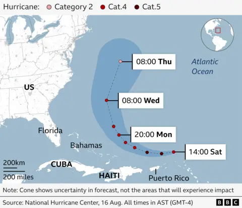
The storm will generate life-threatening surf and rip currents up almost “entire east coast” of the United States next week, said Mr Brennan.
Florida and the mid-Atlantic states will see the most dangerous surf conditions, he said.
Bermuda could also see “life-threatening” surf conditions and heavy rainfall, Mr Brennan added.
Because of gale force winds, the US Coast Guard is imposing restrictions for vessels at ports on the St Thomas and St John in the US Virgin Islands, as well as six municipalities in Puerto Rico, including San Juan.
The National Oceanic and Atmospheric Administration (Noaa), the US government’s primary weather agency, has predicted an “above normal” Atlantic hurricane season this year.
The number of tropical storms that reach category four and five is projected to increase due to global warming.